A 21st Century View of Navigation and NOTAMs
Introduction
From the very start of my flying career, I remember being taught the order of the three main priorities – Aviate, Navigate, Communicate. Even more clearly, I remember the very first exercise of the very first lesson – not the pre-flight inspection or pre-flight checks, but LOOKOUT. These priorities go back a century to the start of aviation and remain as pertinent now as ever. However, aviation has changed enormously in this time with the skies becoming busier than ever before and with new areas of controlled airspace being established on an almost daily basis. Early aviators used to carry a road map or rail map and had little difficulty in being sufficiently sure of their position. Today’s aviator is using a very complex map with so much airspace detail that the geographical features are often not easy to identify. I have flown with pilots who have buried their head in the map for 5 minutes at a time. As the second pilot in the cockpit, I have maintained a lookout whilst watching this activity in wonderment. Once out of the aircraft, however, I have developed a paranoid fear of ever encountering that aircraft in the air. Time spent studying this chart and comparing it with the ground outside is all time taken way from lookout. This is a problem that needs to be tackled effectively.
NOTAMs are a subject which crops up far too often in safety literature. Infringements of temporary airspace are frequently reported and pilots are accused of failing to study the NOTAMs. In particular, cancellation of air displays make the headlines and show general aviation in a bad light. Clearly from the frequency of these occurrences, something needs to be done to improve the situation.
Navigation
With the ever increasing areas of controlled airspace and huge numbers of temporary exclusion zones appearing in the NOTAMs, today’s aviator needs to know his position to a much greater degree of accuracy than his predecessors.
The workload of navigation has become too great to be tackled by traditional methods. Lookout is suffering (greatly) as a result of attempts to navigate by map alone. The tool to solve this problem has been with us for many years now. It is known as GPS. “Not approved”, “Not reliable”, “Takes pilots in a straight line without avoiding airspace”, “Too much head in cockpit”, are just some of the objections raised to its use.
The result is that we send pilots on their first cross country flights without the right tools or training to cope with modern constraints. They (and their instructors) are heavily criticised when it all goes wrong. Meanwhile, the experienced aviator has had to learn for himself how to use a GPS to augment his map reading. Many of these pilots have had to discover for themselves that the commercially available packages are not only expensive , but also contain inaccurate data and have many omissions. Clearly, we need a better solution.
NOTAMs
In parallel with this stone age attitude to navigation, the modern aviator is tasked with appraising himself of hundreds of items of temporary airspace information. The present NOTAM “system” is recognised as a disgrace by all who use it. To call it a “system” is inaccurate. A system implies consistency and logic which would allow the database to be interrogated by a computer and produce reliable filtering. What we have is an arrangement that barely works at all.
The lack of a graphical interface is totally unacceptable. Every day, hundreds of pilots and controllers all over the country grind their way through the same data in order to produce a piece of hand drawn paper showing what matters in their particular area. Hundreds of man hours are wasted and the results are frequently flawed. At best, we are all human, and in many cases we become lazy. This applies not only to pilots, but to air traffic controllers as well. I have spoken to my local ATC unit about a “purple airway” that they had failed to spot in the NOTAMs. We need to eliminate this obvious source of human error.
NOTAM text all too often refers to features that mean nothing to the pilots trying to interpret them. They are not presented in any geographical order. Coordinates given are frequently incorrect, and even when correct are often misleading. Examples include North sea exercise areas with a single coordinate incorrectly entered in the mid Atlantic or parachute drops notified at one village with coordinates given for a point 100 miles further north. The Q line for a recent trigger NOTAM affecting airway P600 at Perth contained coordinates for a point 80 miles further north. Apparently, all trigger NOTAMs are given the coordinates of the weighted centre of gravity of the FIR. Very useful indeed!
Why do these coordinates get mis-plotted? Why has the Q line been added to all NOTAMs. The answer to both questions lies in the “system”. The database is not designed for a graphical interface. In other words, in an environment where the only access to NOTAMs is via computer and phone line, the capabilities of that computer are going to waste.
The Gliding Solution
For many years now, the gliding community has been tackling these problems for its own members. PDAs with built in GPS are now available for as little as £150. Gliding oriented software is available both commercially and as freeware that will depict controlled airspace on a moving map display, showing the gliders exact position in relation to the edges of controlled airspace.
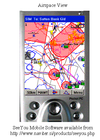
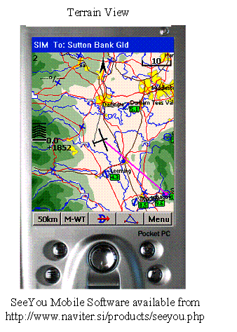
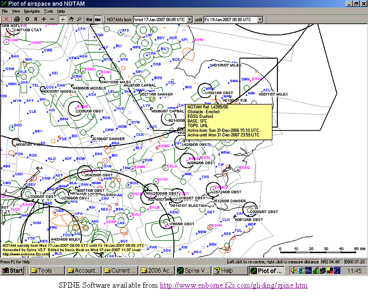
To my knowledge there at least are six programmes available for downloading and interpreting of NOTAM data. All of them aim to give a graphical interface of the data, allowing the user to focus his attention on the NOTAMs in his flight area without needing to trawl through hundreds of entries that are irrelevant to his flight.
All of this gliding oriented software has had a positive effect on the sport. Unintentional airspace penetrations are very few, as are instances of pilots being unaware of NOTAMs. However, at present there is a high degree of risk associated with using such data. The NOTAM interpretation software struggles to cope with the inconsistent presentation of the raw material. The airspace files are produced by volunteers grinding their way through the AIP to extract the data. The data is therefore subject to human error. Updated files are often slow to appear when there are changes to airspace. The data files also struggle to cope with non standard situations such as the fillets where an airway is blended into a control zone. This is in stark contrast to the turn point database which glider pilots use in their task setting. This is centrally maintained and available for free download from the internet to eliminate data input errors. As always, where the input data is wrong, the garbage in, garbage out philosophy applies.
The Way Forward
The purpose of the aviation charts is to allow pilots to identify controlled airspace and to identify their relative position by reference to geographical features. The main purpose of the NOTAM system is to alert aviators to variations from the norm. In both cases, the purpose is to maintain the integrity of reserved airspace by alerting pilots to its presence. The burden of communication lies with the perpetrators of special airspace. If they do not provide suitable tools to the aviator, they are unlikely to maintain the required level of protection to the airspace.
I see a clear route forward from here. The plottable contents of the AIP should be made available for download from the CAA web site in a standard ASCI format. This data should be issued every 28 days to coincide with the AIRAC cycle with a title reflecting its validity period. The software writers only require to know the agreed format in order to provide totally accurate moving map data for pilots.
The cost of this idea is not great. DAP put in a considerable amount of effort to ensuring the accuracy of the revised AIP entries. Their mapping department then has to interpret this data into a graphical format. In doing so, every coordinate required by our software has to be calculated. Meanwhile, radar rooms all around the country are calculating the same coordinates in order to update their screens to reflect the changes. With a suitable format, these coordinates would only require to be calculated once. The master file could then be used in the mapping department, the radar rooms and in the cockpit. The majority of the opportunities for human error would be eliminated and any errors would be consistent amongst all users.
Similarly, the NOTAM system requires to be stored in a format which can be graphically interpreted. Each NOTAM should be written as a discreet ASCI file in the standard format. This would allow the writers of NOTAMs to graphically review their submission. This should eliminate the typographical errors which plague the current system. The central database could then be interrogated to produce a file covering all NOTAMs current for a specific day (part day or group of days). The file could then be viewed graphically, allowing users to read everything that affects them without the need to read the rest. Finally, the NOTAM file, together with the current airspace file can be loaded into a PDA to be used in flight.
The GPS Objection
The overriding objection to this proposal is the current negative attitude towards GPS. Undoubtedly, it has its failings, but they are far fewer than the human failings of the current systems. I doubt there is a pilot in the country who cannot count his total GPS errors on the fingers of one hand. On the other hand, ask yourself honestly how many hands you would need to count the number of times you have been “temporarily unsure of position”. When a GPS fails, the pilot has an accurate idea of their previous position and track. The circle of uncertainty is small. With map and stopwatch navigation, the first indication that something is wrong comes too late. Already, the circle of uncertainty is large. In many areas the corridors between areas of restricted airspace are very narrow. A deviation of only 3 degrees from track can be enough to miss the gap. A visual check that Little Snobville is just left of track is often not enough. If the pilot over-flies Little Snobville and mis-identifies Great Snobville which now lies just to the left of his track, he may already find himself in the middle of an active parachute drop zone or similar.
GPS is here to stay. It is far more accurate and far more reliable than any other current system. The time has come for the authorities to positively advocate its use. It is the way forward and it should be taught as the norm in the modern PPL syllabus. I acknowledge that it has its failings and we should all be prepared to cope if it fails, but it has the potential to be far more effective than the present alternatives. As and when alternative systems become available, they will undoubtedly be able to support the NMEA data stream used by GPS. The moving map technology will not need to change to make use of any such improvements.
Costs
There is a potential for this idea to be killed at birth by profiteering. The airspace database and NOTAM database are both essential tools of aviation. Their purpose is to maintain the integrity of reserved airspace. The costs of promulgating the data must lie entirely with the promulgator. In the case of NOTAMs, this would be automatically achieved by insisting that NOTAMs are submitted as usable data files in the standard format. In the case of standard airspace data, this proposal places some additional work with DAP. However, it eliminates a great deal of duplicated work at ATC centres and should integrate with the existing mapping system.
It is imperative that this data is available for free download if pilots are to take advantage of the ability to always fly with current data.
Summary
Our skies are crowded and full of very complex airspace arrangements. We need a system that will allow users to be 100% sure of their position relative to (invisible) airspace boundaries whilst allowing them sufficient time to maintain a good lookout. The solution lies with a combination of GPS, moving map software/hardware and officially endorsed data files. Naturally, this equipment needs to be backed up by the traditional chart, and the pilot should keep track of his position on the chart as well as on his moving map display, but the time has come to recognise the chart as the backup and not as the primary reference. I don’t claim to have all of the answers, but I hope that this paper will encourage others to work with me to produce a robust and cost effective solution.
About the author
I am a soaring pilot. I believe that the sky and the atmosphere are the most fascinating, beautiful and enjoyable of playgrounds. I fly around 200 hours per year covering 10,000 cross country kilometres over much of mainland Britain and the Scottish islands, operating at all levels up to FL245. In the gliding environment, I encounter pilots from other branches of GA, commercial pilots and air traffic controllers. These views, however, are very much my own and stem from my experiences in gliding.
January 2007